Visibility is the basis of meaningful outreach.
If your team can’t find vulnerable people, you can’t develop sustainable and effective strategies for care. If field workers can’t find folks who are unhoused, they can’t offer food, socks, sunscreen, or other essentials to meet pressing needs. As providers, you need a tool that creates this visibility.
In the past, identifying encampments, prioritizing services, and coordinating care for clients was a herculean task that came with mountains of paperwork. Until recently, it was nearly impossible to keep track of the rapid evolutions that occur in homeless populations, in part because there was no good tool to visualize them.
Geographic information system (GIS) technology is changing that. It sheds light on where unhoused individuals are staying, what they need, and in some cases, where they might be heading. It can help predict large-scale shifts in homeless populations and drill down to the most urgent needs at specific encampments. It enhances the full scope of a community’s efforts to prevent homelessness, from policymaking to reporting to client care.
In other words, GIS brings visibility to the fight to end homelessness. And, ensuring that people in need aren’t invisible to their communities is the first step to connecting them with resources, support systems, and eventually, housing.
Thank you for joining the Bitfocus team as we explore how GIS is changing the nature of homeless outreach. We’ll cover the basics of GIS, explore how location data can empower providers on the front lines, and explain how it facilitates relevant care for clients. Plus, if you stick around, we’ll give a few real-world examples of how Clarity Outreach — a fully integrated module of our HMIS — has contributed to front-line care.
What Is GIS?
Before we dive into the details, let’s take a quick look at GIS from a 30,000-foot view.
GIS is a visualization system. At any given location, it helps teams understand the relationship between:
- Geographical characteristics (terrain, city infrastructure, etc.),
- Intangible characteristics (jurisdictional boundaries, law enforcement zones, etc.), and
- Human characteristics (distribution and movement of people).
In the rapidly evolving realm of homeless outreach, GIS brings vital context. Where are vulnerable populations? Where are they going? What hotspots are likely to have urgent needs? How can we best connect them with care?
A GIS-driven platform like Clarity Outreach provides the foundation for answering questions like these. It captures how things are changing in real time, unlocking a wealth of benefits for providers, clients, and communities.
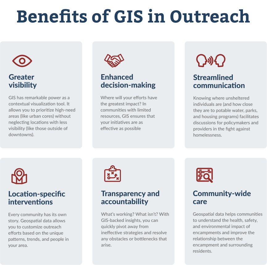
The Virtues of GIS-Driven Homeless Outreach
A better understanding of geographic context leads to better outcomes. Providers who leverage geospatial insights can offer stronger care to people who need it most.
Location Intelligence: A New Perspective on Community Care
At Bitfocus, we refer to this process — the collection and analysis of spatial data to inform decision-making — as Location Intelligence.
Location Intelligence introduces data points beyond those that are observed. That added visibility empowers communities to take a strategic and equitable approach to encampment resolution initiatives.
“As providers, Location Intelligence calls on us to expand our view of unsheltered homelessness by considering the full scope of its complexity and the myriad factors that contribute to it. Then, we can use that information to find the best way to prioritize and allocate resources accordingly.” – Marti Phillips, Senior Project Manager at Bitfocus
Practical Applications of GIS in Homeless Services
GIS is stellar as a visualization tool. Where it really shines, though, is in its integration with outreach efforts. After all: A fancy new tool is only as useful as its application on the ground.
GIS-driven mapping and outreach can help you:
- Locate clients in real time. Let’s say you and a client need to upload a document before a crucial deadline to qualify for a housing program. Instead of wasting precious time trying to get in touch with them, you know where they’re located and you can efficiently collect the information needed to get them housed.
- Identify specific needs. For outreach workers, the ability to provide targeted support is a victory. Whether a client is looking for food, clothing, medical care, or help arranging childcare, GIS helps you locate them and paint a clear picture of what they need.
- Collaborate across outreach teams. By mapping out encampments, creating profiles for the folks who live in each one, and logging outreach efforts in an area, you can coordinate services to ensure that nobody falls through a gap in your outreach.
- Prioritize resource distribution. Unsheltered clients aren’t just harder to reach — they’re also more vulnerable than sheltered clients. Geospatial data enables you to allocate resources according to client needs rather than your ability to locate them.
- Track emergency responses. GIS enables a swifter response in time-sensitive situations. If a blizzard is rolling in, you’ll be able to distribute hats, gloves, and other provisions, and get people to safety before the frigid air arrives.
Homeless Outreach Case Study: Cuyahoga County
Before implementing Clarity Outreach in October 2023, a Bitfocus customer in Cuyahoga County, Ohio, had little confidence in their unsheltered data because the majority of it was collected outside of their HMIS.
Since implementing Outreach, the community has mapped and assessed many known homeless encampments in the region. As they continue on in their work, they are confident that Outreach will provide greater insight into the unsheltered population in their community and be a strong foundation for their continued outreach efforts.
Powered by GIS, Outreach now provides a single source of truth for their community, allowing them to coordinate providers and deliver services more effectively.
“Bitfocus and their Outreach module have provided our community with some phenomenal tools to start tracking and evaluating what unsheltered homelessness truly looks like in our community. With the cooperation of our outreach providers, our goal is to be able to provide services more effectively to those in need and data to support the great work our community does. Bitfocus and their project team were fantastic in assisting us with getting this software up and running – everything from information gathering to training to implementation was handled perfectly.” - Nick Butina, HMIS System Administrator
Optimizing Outreach with Clarity HMIS’s GIS Features
As system administrators ourselves, we know the importance of having an intuitive, user-friendly HMIS that empowers providers in their outreach efforts. We designed Clarity Outreach to that end.
Built on the ESRI ArcGIS platform for mapping and analytics, Clarity Outreach is a fully integrated module of Clarity Human Services that provides a geospatial representation of unsheltered homelessness and encampments. It’s built to give you as much Location Intelligence as possible.
With Clarity Outreach, communities can better allocate resources, identify gaps in services, and ensure consistent coverage across all unsheltered populations. Here are a few of the features that contribute to these capabilities.
Encampment Assessment
When conducting an encampment assessment, you might ask questions like:
- Does this encampment have access to potable water?
- Is it located near sanitation facilities?
- What’s the level of debris at this location?
Data points like these will inform your service plan for the encampment and improve your community’s understanding of unsheltered homelessness as a whole.
Many communities are developing encampment assessment tools that are tied to location data. This integration will strengthen insight into what’s causing unsheltered homelessness and how it can best be prevented. Crucially, location data brings an element of personalization to outreach efforts — communities can tailor services to individual needs and encampments as well as the population as a whole.
Map Overlay
Clarity allows you to import and create map layers that give you a better understanding of homelessness in your area. Common map layers include:
- CoC map layers (especially useful for multi-CoC implementations),
- Local congressional districts,
- City council districts,
- Law enforcement zones,
- Fire department service areas,
- FEMA flood zones,
- Public parks,
- And more.
By leveraging ArcGIS, you can also create and import customized map layers like:
- Outreach zones,
- Safe sleeping zones,
- “No camping” enforcement areas,
- And more.
Zones like these improve your reporting and help your outreach personnel coordinate services. Equally important, Clarity’s granular map overlay functionality allows you to tailor reports to specific stakeholder groups to build awareness, showcase progress, and secure more funding.
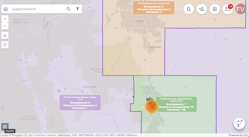
Clarity with CoC map layers turned on — a built-in feature for all Outreach users!
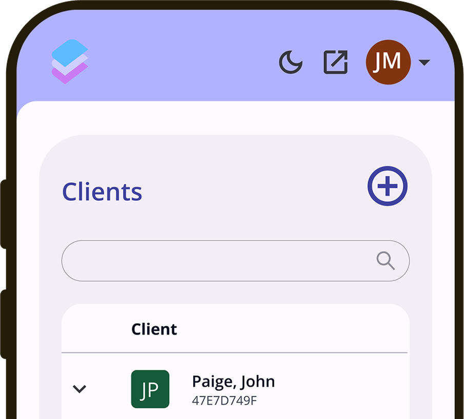
Location Tab
Clarity Outreach allows you to record and view client location data in various formats. The Location Tab displays past information, like the staff member who last updated the location, the location type, the location date, and whether the location appears in Outreach. This tab keeps a running log of every location where the client has interacted with a provider, along with services they’ve received, all in one place.
This information provides vital context around each individual’s journey with homelessness and helps outreach teams understand which efforts have been most successful in supporting their clients.
Notes and Alerts
The Notes and Alerts feature updates providers on emergencies and urgent situations in the field in an efficient, organized, and well-documented way.
Because we understand that your community is unique, our team at Bitfocus will work with you to create operational definitions and protocols based on your local context and the nature of a situation, whether it is:
- Threats of violence against staff or residents,
- An aggressive animal in the area,
- Environmental risks such as flooding or fire,
- Or another emergency situation.
When an alert is created, Clarity Outreach automatically sends a notification to all assigned users so that everyone is on the same page right away. We also encourage communities to create daily scheduled reports of active alerts that go out to all outreach personnel.
In the spirit of providing your team with as much helpful context as possible, Clarity Outreach stores alert activity within encampment profiles so outreach staff can review the encampment history.
Enhancing Coordinated Entry with GIS in Clarity HMIS
In many communities, outreach is a siloed intervention with few connections to coordinated entry. Isolating outreach in this way doesn’t just lead to inefficiencies like duplication of services — it can prolong episodes of homelessness by making it harder to locate clients when housing availability opens up.
That’s why our team favors an integrated approach. Real-time location data equips outreach personnel, coordinated entry matchmakers, and navigators to quickly find clients who have been slated for services and housing.
Ultimately, building these bridges between coordinated entry and outreach leads to better outcomes for vulnerable populations, helping them find housing while minimizing friction and delays.
Protecting Client Data: An Ongoing Conversation
No doubt, location data empowers providers to give better care. But it also presents a challenge: How can communities leverage the power of data in an ethical manner?
After all, effective outreach is based on trust. To earn the trust of clients (and providers!), communities must implement strong policies and procedures geared at developing a culture of data responsibility.
Here are the key topics of the conversations our team at Bitfocus has been having:
- Client consent to collect: Because Clarity Outreach provides new opportunities to visualize unsheltered homelessness, some communities are revamping their ROIs to ensure that clients are sufficiently protected.
- Access to Outreach module: Outreach contains exact encampment locations. Many communities are restricting map access to need-to-know staff in an effort to appropriately safeguard client information.
- Sharing of location data: A top priority for clients and providers is guaranteeing that client location data is protected outside of HMIS and won’t fall into the hands of law enforcement or court systems.
At Bitfocus, we know that protecting client data is of paramount importance. We’ve worked hard to ensure that Clarity Outreach keeps client information between clients and need-to-know staff only, cultivating trust and nurturing relationships in the field.
We’re excited about the resurgence of conversations around ethical data collection, and we’d love to hear your thoughts on the topic! Send us a message at info@bitfocus.com, and we’ll gladly discuss data responsibility with you.
Embracing the Future of GIS-Driven Outreach
Integrating HMIS with GIS unlocks countless opportunities for better care. Here are a few we’re most excited about.
Enhanced Data Collection
Geospatial analytics don't just tell you what's going on, they tell you where it's happening. Based on that information, your team can make informed decisions on how best to address situations within local and hyper-local contexts.
Improved Targeting and Prioritization
Equipped with granular information, your outreach personnel can ensure consistent coverage of your community. You’ll be able to prioritize encampments and individuals according to their degrees of need, and prevent individuals — even those on the outskirts of a major city or in a rural area — from slipping through the cracks.
Stronger Collaboration
Unsheltered homelessness is complex. Organizations need powerful tools like GIS to help them visualize the intricacies of homelessness within a community or encampment. As communities share this data through private and secure channels, they’re able to work together to win the battle against homelessness in their area, one person at a time.
Elevate Your Outreach with Clarity
Thank you for joining us! We’ve enjoyed exploring the impacts of GIS technology on homeless outreach, and we hope you gained some fresh perspectives on geospatial analytics.
At Bitfocus, we believe that technology should free you to focus on your people — and there’s no better way to empower your people than by bringing much-needed visibility into your outreach efforts. If you’d like to learn more about how Clarity’s GIS-driven Outreach module can help you care for your community, reach out to us today and we’ll find a good time to talk.
We can’t wait to hear from you!